Two Deserts, One Park: Why Joshua Tree Changes as You Drive Through It
From Cottonwood and the cholla garden to the higher Joshua tree country, a drive through the park reveals two deserts—and the places where they overlap.

Enter Joshua Tree National Park from the south and a reasonable question may occur to you: where are the Joshua trees?
The road opens onto broad desert country. Shrubs spread across the ground. Ocotillo canes lift into the sky. Farther along, a dense gathering of cholla makes a landscape of its own. The branching trees that gave the park its name become part of the scene in the higher country.
You have not taken the wrong entrance. You are watching one of the park’s defining features unfold: the meeting of the Colorado and Mojave deserts. Once you know what to look for, the drive becomes more than the distance between stops. It becomes the story.
- Joshua Tree protects parts of two deserts: the lower Colorado Desert, a subdivision of the Sonoran, and the generally higher Mojave Desert.
- Elevation helps explain the change, but water, soil, exposure and local terrain shape what grows at each stop.
- The transition is an overlapping zone, not a sharp line at a road sign or a particular elevation.
- A south-to-northwest drive dips toward Pinto Basin before climbing; it is not an uninterrupted ascent.
The park’s name tells only half the story
“Joshua Tree” encourages us to picture one landscape: angular trees, enormous rounded rocks and open sky. That scene is real. It just does not represent the entire park.
The National Park Service describes a broad contrast between the lower Colorado Desert in the east and the higher Mojave Desert in the west. The Colorado Desert is part of the larger Sonoran Desert; here, “Colorado” names a desert region, not the state. [1]
Colorado Desert
Think lower basins, broad views and plants such as creosote, ocotillo, palo verde and cholla. This is a full desert landscape with its own character, even where the park’s namesake tree is absent.
Mojave Desert
Think generally higher, cooler country, with Joshua trees as a familiar indicator. In the park’s uplands, the plant community can also include pinyon and juniper. Every Mojave scene is not identical, either.
The two descriptions are useful starting points, not sealed compartments. NPS emphasizes that species overlap across the transition. That qualification is essential to reading the park well. [1]
Why a few miles can change the view
Start with elevation. Higher terrain is generally cooler, and that changes the conditions plants experience. But height is only one part of the explanation. A plant also has to cope with the timing of moisture, the soil beneath it and the exposure of its particular patch of ground.
The larger setting matters. Mountain ranges to the west help create a rain shadow: rising air loses moisture on the windward side, leaving drier conditions farther inland. Within that dry setting, rain arriving at different times of year—and the rate at which moisture is lost—helps shape desert life. [2]
Then look more closely. Runoff can concentrate water on an alluvial fan. A spring can support an oasis. A plant can spread successfully in a particular pocket. These local stories sit inside the regional story; they do not replace it.
This is why “above 3,000 feet is one desert, below it is the other” is too tidy for the view through your windshield. That elevation is a useful broad orientation in park interpretation, not a botanical checkpoint. [1]
Read the landscape in three stops
For a visit from the Coachella Valley, the southern approach makes the contrast especially easy to follow. Begin in the Cottonwood area, continue north on Pinto Basin Road past Cholla Cactus Garden, then turn west onto Park Boulevard toward Hall of Horrors. Use the official park map alongside this guide.
The map below marks three reference points, not a hiking route or the boundary between deserts. Check current NPS road, trail and area conditions before you go; a stop shown here may have access restrictions. [9]
A drive through changing habitats
Three stops. Three different scenes.
Follow these stops from south to northwest: Cottonwood, Cholla Cactus Garden, then Hall of Horrors. Select a stop to compare its landscape and elevation.
The road descends toward Pinto Basin before climbing into the higher country. Bars show approximate elevation at each mapped reference point, not a continuous road profile. USGS elevation notes.
Stop 1 · Colorado Desert · approximately 3,000 ft
A local pocket of water
Start by separating two scales: the dry region around you and the spring-fed habitat within it. Cottonwoods and fan palms at the oasis tell a local water story; they do not turn this part of the park into a different desert.
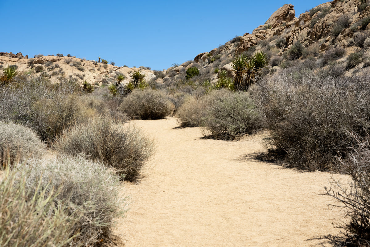
Look for: Compare the vegetation near the spring with the shrubs on the surrounding slopes.
On foot: The short spring walk is about 0.1 mile from its parking area. Respect closed habitat and stay on the designated route.
Stop 2 · Pinto Basin transition · approximately 2,200 ft
The desert changes in patches
Notice the concentration of teddy bear cholla against the much more open basin beyond. The garden sits in the transition area, but this dense stand is also a local colony: fallen stem segments can take root nearby.

Look for: Look for the contrast between a dense cactus stand and the open ground beyond it. A patch is not a boundary line.
On foot: When open, the designated loop is about 0.25 mile. Keep clear of spines and fallen segments; this is an exposed stop with no shade.
Stop 3 · Higher Mojave Desert · approximately 4,300 ft
Joshua trees enter the picture
The trees and rounded granite now make a very different scene from the lower basin. Use the open views around the designated parking area to notice the branching yuccas, their spacing and the vegetation among the rocks.

Look for: Find the tree-shaped yuccas with stiff leaf clusters at the ends of their branches. Compare this skyline with the cholla garden.
On foot: You do not need to enter narrow rock corridors or scramble onto boulders to make this comparison. This is a landscape stop, not a climbing route.
Those elevations reveal a small surprise. Cottonwood’s mapped reference is higher than the cholla garden’s. The overall journey takes you from lower desert country into the higher Mojave, but the actual road first carries you down toward the basin. Terrain has folds, not a single slope. [10]
Four clues to notice along the way
1. A green pocket does not describe the whole region
At Cottonwood Spring, water supports cottonwoods, fan palms and bird habitat. The contrast with the surrounding dry country is the point. Stay on the designated short approach and respect closures around the spring; protected habitat is not an invitation to explore off trail. [3]
2. Bare-looking ocotillo may simply be between rains
Ocotillo is not a cactus. Its tall, slender canes can carry leaves after rainfall and lose them again as conditions dry. The same plant can therefore contribute a very different texture to the landscape on another visit. Flowers are seasonal, not something a drive date can guarantee. [4]
At the signed Ocotillo Patch along Pinto Basin Road, NPS points to runoff on an alluvial fan as part of the explanation for the concentration of plants. It is a useful extra pullout between the Cottonwood area and the cholla garden, when access allows. [5]
3. The cholla garden is a colony, not a desert-wide pattern
The density of teddy bear cholla is memorable precisely because it contrasts with the open country beyond. Detached stem pieces can root near the parent plant. That helps explain a clustered stand without implying that every mile of the surrounding desert should look like it. Keep shoes and hands clear of fallen segments as well as standing plants. [6]
4. Joshua trees are clues, not survey markers
A Joshua tree is a tree-form yucca. Its presence is a strong visual cue to Mojave habitat, but an individual tree does not mark the exact beginning of an ecosystem. NPS lists a broad elevation range for Joshua trees within the park, and their distribution extends beyond its boundaries. [7]
Once you are in the higher country, look at more than the trees. The rocks, spaces between plants and smaller vegetation all contribute to the scene. Our guide to why Joshua Tree’s rocks look like that explains the other unmistakable half of the view.
The most interesting place is the overlap
It is natural to want a moment when one desert stops and the next begins. Nature does not owe us that convenience.
In the park’s Where Two Deserts Meet podcast, the transition-zone discussion with ecologist Cameron Barrows makes this especially clear: the change is not a fixed line, and some familiar plants occur across both landscapes. Creosote, for example, is not a reliable sign that you are exclusively in one desert. [8]
That changes the question worth asking. Instead of trying to locate a boundary to the nearest mile, ask what has become more common, what has become scarce and what conditions might explain the difference. The pleasure is in noticing the pattern—and then noticing the exceptions.
Give the drive room to be a visit
This works best as a landscape day with time to stop, not a fast crossing with three boxes to check. Travel in daylight, use designated parking and pullouts, and leave enough time to return safely. Short walks still mean exposure to desert conditions.
- Plan for the whole park’s weather. Conditions can differ substantially with elevation. Check the forecast and park alerts for the areas you intend to visit, rather than assuming the Coachella Valley forecast describes every stop.
- Bring water and food; fuel up before entering. Do not plan on restaurants or gas stations inside the park. Heat, wind or closures can make a shorter visit the better choice.
- Download the park map before you lose service. Treat this article’s map as orientation. Current signs, closures and ranger guidance take precedence.
- Keep the comparison simple. You do not need a long hike, a rock scramble or a perfect bloom to see the change. A safe stop and a few attentive minutes can be enough.
Use the NPS conditions page, weather guidance and visitor FAQs to finish your plan. [9]
The reward is a different way of remembering Joshua Tree. Not just a famous tree against a rock, but a succession of landscapes: a water-fed pocket, a broad basin, a cholla colony, then branching silhouettes in the higher country. One park holds all of them.
Frequently asked questions
What two deserts meet in Joshua Tree National Park?
The Mojave Desert and the Colorado Desert meet in the park. The Colorado Desert is a subdivision of the larger Sonoran Desert. In broad terms, the park’s western country is higher Mojave habitat and its eastern basins are lower Colorado Desert habitat, with overlap between them.
Why are there no Joshua trees near parts of the south entrance?
Much of the southern approach is Colorado Desert country. Joshua trees are associated primarily with Mojave habitat and are not distributed uniformly through the park. Their absence does not mean you have missed the park; it is a clue that you are seeing a different part of it.
Is Cholla Cactus Garden the exact boundary between the two deserts?
No. NPS places the garden in the transition area, but that transition is not a precise line. Local soil, terrain, moisture and the way cholla reproduces also help shape this particular stand.
Does the drive from Cottonwood to the Joshua trees climb the whole way?
No. The route descends toward Pinto Basin before climbing into higher country. At the mapped reference points in this guide, Cottonwood is approximately 3,000 feet, Cholla Cactus Garden 2,200 feet and Hall of Horrors 4,300 feet. These are rounded stop elevations, not a continuous road profile.
Can I see the landscape change without taking a long hike?
Yes. Much of the comparison comes from the paved park roads and designated stops. Cottonwood Spring has a short approach and Cholla Cactus Garden a short loop when open; you can appreciate the higher landscape without scrambling into Hall of Horrors’ rock corridors. Check current closures, weather and each stop’s access before visiting.
Sources and field notes
Research checked October 24, 2026. Landscape interpretation draws on National Park Service resources. Photographs are by Mark Miller; they show conditions at the time photographed and do not guarantee current blooms or access.
- Park ecosystems and the two-desert overview
National Park Service park brochure; broad elevation patterns, plant communities and overlapping transition.
- Desert climate and the rain shadow
National Park Service explanation of desert climate, precipitation and the regional rain shadow.
- Cottonwood Spring short walk
National Park Service; spring habitat, short approach and protected-area restrictions. The short spring walk is distinct from longer routes in the Cottonwood area.
- Ocotillo
National Park Service; plant identity and changes in leaves with moisture.
- Ocotillo Patch
National Park Service place description; Pinto Basin Road pullout and runoff on an alluvial fan.
- Cholla Cactus Garden
National Park Service; transition-area setting, short loop and growth from fallen segments. Check current conditions for access; historic closure notices are not treated as current status.
- Joshua trees
National Park Service; yucca identity, habitat and distribution. Elevation is an ecological guide, not an exact desert boundary.
- Where Two Deserts Meet: Transition Zone
National Park Service podcast, March 11, 2023, featuring ecologist Cameron Barrows; overlapping habitats and why there is no sharp dividing line.
- Current conditions and visitor planning
National Park Service current conditions. Also consult the official park map, weather guidance and visitor FAQs linked in the article; no real-time access guarantee is made here.
- Approximate stop elevations
USGS Elevation Point Query Service, sampled October 24, 2026 at existing DOI shared-map reference points. Cottonwood: 2,987.7 ft; Cholla Cactus Garden: 2,193.1 ft; Hall of Horrors: 4,339.9 ft. Rounded to the nearest hundred feet in the guide. These are terrain elevations at reference points, not surveyed signs, trail profiles or ecological thresholds.
Map locations reuse DOI’s existing shared place records for the Cottonwood Spring parking reference, Cholla Cactus Garden area and Hall of Horrors parking reference. Satellite imagery: Esri, Vantor, Earthstar Geographics, and the GIS User Community. No ecological boundary or off-road route is drawn.
