








Why Parts of the Desert Look Paved: Desert Pavement
The stones, dust and living surfaces beneath an apparently empty landscape.

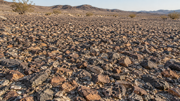
The desert can look unexpectedly finished. Small stones fit close together across a broad surface, almost as though someone had laid them down. There are no straight joints or tidy borders, but the ground has the look of a rough mosaic.
One name for this natural surface is desert pavement. The visible stones are only part of it. Fine material underneath, the movement of dust and water, and the history of disturbance help explain what you are seeing.
Once you begin noticing those differences, the ground becomes as interesting as the mountains.
- Desert pavement is a natural surface of closely packed stones.
- Dust can accumulate beneath the cover; erosion is only part of the formation story.
- Stone arrangements, rock coatings and biological soil crusts are distinct features.
What makes it desert pavement?
The National Park Service describes desert pavement as a closely packed surface layer of coarse pebbles and gravel. It is a natural arrangement of rock fragments, rather than constructed paving.
Look for the pattern across a patch of ground, not just one dark stone. A gravelly wash, landscaped rock bed and pavement surface may all contain stones, while recording different processes. The term describes a surface whose organization needs explaining. [1]
The wind story has a surprising second half
The familiar explanation begins with removal: wind or water takes away smaller particles, leaving larger fragments behind. That process can help create a stony surface. The rock cover can then shelter finer material from further wind erosion. [2]
But erosion alone does not explain every pavement. A 2025 scientific review emphasizes dust accumulation: fine material arrives, is trapped among stones, and is incorporated beneath them. The soil can grow thicker while stones remain at the surface. The pavement is part of an evolving soil system, not simply what remains after everything fine has blown away. [3]
Classic research on the Mojave Desert’s Cima volcanic field found windblown dust accumulating beneath surface stones derived from basalt. That gives us a different way to imagine the ground: material is being added below the stone cover, not only removed from around it. [4]
Look beneath the stone mosaic
This cross-section separates the visible cover from the finer soil underneath. Select a layer to highlight it. It is a conceptual profile, not an excavation or a measured location.
The diagram explains a relationship, not a universal recipe. Pavement development varies with the starting material and local conditions; it should not be reduced to one process operating everywhere. [3]
Pavement, varnish and living crust are different things
Three features can be close together in a desert photograph. They answer three different questions about the surface.
Desert pavement
The arrangement of stones. Look across the ground for a closely packed surface layer. Its defining feature is the cover of fragments, not a particular color.
Desert varnish
A coating on rock. Thin coatings can darken exposed surfaces. Rock varnish includes clay minerals and iron and manganese oxides; the processes concentrating them are not fully understood. A dark stone alone does not establish its coating or age.
Biological soil crust
A living soil community. Cyanobacteria, lichens, mosses and other organisms can bind soil near the surface. Young crust can be inconspicuous; mature examples may be dark and textured. It is not a layer of gravel.
Rock coatings are described by the National Park Service separately from biological soil crusts. Appearance helps you notice a feature; it does not replace identification. [5] [6]
Why can a track last so long?
A stone-covered surface can seem durable enough to shrug off anything. Yet moving the stones or compacting the underlying soil changes the surface that took time to develop.
A study published in 2002 examined Mojave Desert sites disturbed by World War II military training about 55 years earlier. Vehicle tracks were still visible, particularly in desert pavement. The tracked soils differed from adjacent ground in rock distribution and penetrability; the researchers estimated that restoring the pavement could take centuries.
That is a finding from the studied sites, not a stopwatch for every footprint or tire mark. It does explain why an old disturbance can remain part of a desert view long after the activity ends. [7]
Our Camp Young story follows the military history east of Indio. The pavement research adds a physical question: what did repeated movement do to the ground? An isolated track still needs evidence before we can call it a wartime feature.
The surface helps decide what becomes dust
In a study of 87 sites in two western U.S. deserts, researchers compared sediment movement before and after vehicle disturbance. Undisturbed rock-covered or well-developed crusted surfaces were especially stable; disturbance could make sediment easier to move. Responses depended on the site. [8]
That connects the small view at your feet with the larger one toward the mountains. Our dust and air-quality explainer looks at airborne particles. Pavement asks an earlier question: what holds material on the ground?
Our story about moving sand explores habitats that depend on sediment supply. Different surfaces have different roles. Understanding those roles is more useful than treating all open desert as the same material.
Connect the surface to the surrounding landscape
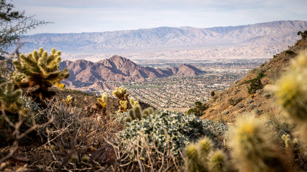
Begin with the broad view. Where are the mountains, washes and more level surfaces? Then look closer: is the ground covered in tightly spaced fragments, loose sand, fresh gravel or a textured crust?
The Santa Rosa Mountains provide a useful setting for thinking about rock sources and valley margins. The Coachella Valley Preserve provides another way to observe contrasts among vegetation and sediment from established routes. These are landscape connections, not verified pavement study sites.
Continue with how canyons build the valley floor. A fan’s overall shape and the surface resting on it are different scales of the same landscape. Likewise, groundwater-related subsidence concerns movement beneath the surface; a stone mosaic by itself does not demonstrate subsidence.
Photograph the pattern without changing it
Make two compositions from an established route: a wider view that places the surface in the landscape, and a closer view showing how the fragments fit. Low-angle light can reveal edges and small shadows; light from a different direction may make the same patch read very differently.
Keep the arrangement intact. Do not clear a patch, turn stones over or create a track to illustrate the story. Avoid stepping onto biological crust to get a closer photograph; follow the site’s route guidance.
A useful caption records the location, date and visible features. If the surface has not been identified, “closely packed stones beside the trail” is more accurate than assigning a formation process, age or historic event from its appearance.
The reward is a different kind of desert photograph. The horizon still matters, but now the foreground carries a story of its own.
Questions about desert pavement
Is desert pavement made by people?
No. The term describes a natural stone-covered surface. Constructed rock beds and roads can look superficially similar, so context matters.
Does wind simply blow the sand away and leave stones?
Removal of fines can contribute, but it is not a complete explanation for every pavement. Research also documents dust accumulating beneath the stone cover.
Is desert pavement the same as desert varnish?
No. Pavement describes a surface arrangement of rock fragments. Varnish refers to coatings on rock. A pavement’s stones may have coatings, but the terms describe different features.
Is biological soil crust just another name for gravel?
No. Biocrust is a living community near the soil surface. It may include cyanobacteria, lichens and mosses, and can be difficult to recognize when young.
Can I tell how old a surface is from a photograph?
Not reliably. Appearance alone cannot give a dependable age or establish that a track came from a particular historical event. Those questions require site-specific evidence.
Sources and image notes
Sources reviewed October 27, 2026. Regional research examples explain processes; they do not establish the age or condition of an unexamined Coachella Valley site.
- National Park Service, Arid and Semi-arid Region Landforms. Definition of desert pavement and related desert landforms.
- USGS, Eolian Processes. Traditional deflation explanation and protection provided by a rock mantle.
- Fuchs and colleagues, Desert pavements: A hidden key to Earth surface processes (2025). Modern review of dust accumulation, soil horizons and interacting processes. The cutaway is an original simplified illustration, not a reproduction of a research figure.
- McFadden, Wells and Jercinovich, Influences of eolian and pedogenic processes on the origin and evolution of desert pavements (1987). Research on dust and pavement development in the Cima volcanic field.
- National Park Service, Desert Varnish. Rock coatings and the limits of identifying them by appearance.
- National Park Service, I Didn’t Know That! Biological Soil Crusts. Living crust organisms, appearance and avoiding disturbance.
- Belnap and Warren, Patton’s tracks in the Mojave Desert, USA: An ecological legacy (2002). Observed WWII-era vehicle disturbance roughly 55 years later. The study’s recovery estimate is not applied to every desert surface.
- Belnap and colleagues, Controls on sediment production in two U.S. deserts (2014). Wind-tunnel comparisons at 87 sites before and after vehicle disturbance.
Image notes: The featured image is an AI-generated editorial illustration of a stone-covered desert surface, not a photograph of a verified pavement site. It is a temporary placeholder for original photography. The interactive cutaway is conceptual and not to scale. No image is used to establish a deposit’s age, composition or formation history.


